
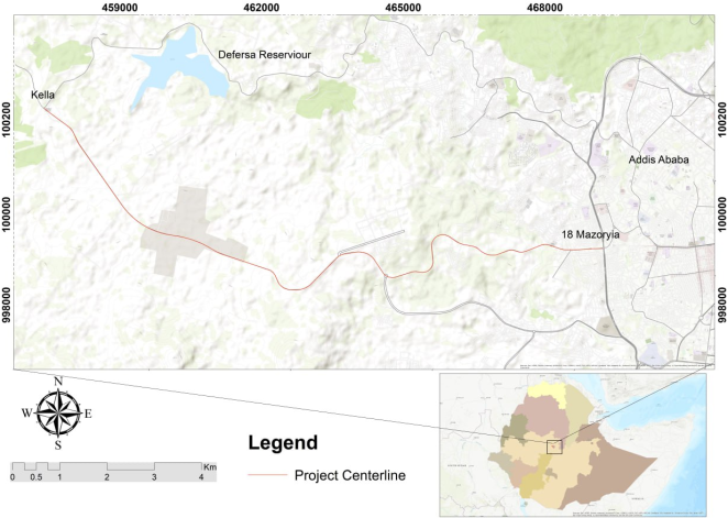
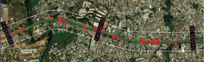
Road traffic crashes represent a critical public health and safety concern in rapidly urbanizing regions across Ethiopia, mainly affecting vulnerable road users. This study assesses the safety impacts of proposed multimodal and geometric corridor development interventions along the high traffic 18 Mazoria-Ashewa Meda Corridor in Addis Ababa. Using a mixed-methods, historical crash data across 12 equal segments (500m length), field observations, regression modeling and stakeholder perception surveys were analyzed. The assessments revealed severe infrastructure deficiency: 83.3% of segments lacked continuous walkways and 100% lacked dedicated bike lanes and bus bays. Major junctions were strongly correlated with crash severity (r=0.688, p=0.013). multiple regression modeling confirmed major junctions as the dominant predictor of the Weighted Severity Index (B=40.214, p=0.02). Segment 11 (Kidanemihret roundabout) emerged as the primary blackspot (Crash Frequency (CF)=36, representing 31.3% of total crashes) due to steep gradient (~7%) and substandard geometry. Given the absence of post-intervention crash data and data limitation, Crash Modification Factors (CMFS) from the FHWA Clearinghouse and the Highway Safety Manual (HSM) were applied to project safety benefits. The projected interventions demonstrate expected reductions of 32% for dedicated bike lanes (CMF=0.68), 65% for continuous walkways (CMF=0.35), 44% for right-turn geometry modification (CMF=0.558), and 68% for left-turn/ U-turn geometry prohibitions (CMF=0.32). The hazardous Kidanemihret roundabout redesigned into a priority junction to eliminate heavy vehicle rollover risks on steep gradients. Statical evidence, CMF projections and stakeholder perceptions collectively indicate that the interventions will improve road safety.
| Published in | American Journal of Traffic and Transportation Engineering (Volume 11, Issue 4) |
| DOI | 10.11648/j.ajtte.20261104.11 |
| Page(s) | 61-66 |
| Creative Commons |
This is an Open Access article, distributed under the terms of the Creative Commons Attribution 4.0 International License (http://creativecommons.org/licenses/by/4.0/), which permits unrestricted use, distribution and reproduction in any medium or format, provided the original work is properly cited. |
| Copyright |
Copyright © The Author(s), 2026. Published by Science Publishing Group |
Road Safety, Crash Modification Factors, Vulnerable Road Users, Weighted Severity Index, Corridor Development, Non-Motorized Transport, Addis Ababa
Geometric elements | Value/Range | N | Variation |
|---|---|---|---|
Lane width | 3.5m (constant) | 12 | 100% (no variation) |
Number of lanes | 2 to 4 | 12 | 2 lanes: 83.3%, 4 lanes: 16.7% |
Shoulder width | 0 to 1.5m | 12 | Mean = 1.25m, SD = 0.5839 |
Walkway present | Yes = 2 segments, No = 10 segments | 12 | 16.7% present, 83.3% absent |
Bike lane present | 0 segments | 12 | 0% (constant) |
Bus bay present | 0 segments | 12 | 0% (constant) |
Major junction present | Yes = 2 segments, No = 10 segments | 12 | 16.7% present, 83.3% absent |
Model | R | R Square | Adjusted R Square | Std. Error of the Estimate |
|---|---|---|---|---|
1 | .697a | 0.486 | 0.372 | 16.81281 |
Model | Unstandardized Coefficients | Standardized Coefficients | t | Sig. | Collinearity Statistics | |||
|---|---|---|---|---|---|---|---|---|
B | Std. Error | Beta | Tolerance | VIF | ||||
1 | (Constant) | 19.464 | 16.51 | 1.179 | 0.269 | |||
Major junction | 40.214 | 14.209 | 0.738 | 2.83 | 0.02 | 0.84 | 1.19 | |
Number of lanes | -3.393 | 7.105 | -0.124 | -0.478 | 0.644 | 0.84 | 1.19 | |
Proposed Countermeasure | Applied CMF | Projected Crash Reduction | Target Crash Type | Source |
|---|---|---|---|---|
Dedicated Bike Lanes (2m) | 0.68 | 32% | Vehicle-Bicycle Collisions | FHWA Clearinghouse [ 7, 9] |
Continuous Walkways (5m) | 0.35 | 65% | Pedestrian-Vehicle Collisions | FHWA (ID: 1337) [ 8] |
Right-turn geometry modification | 0.558 | 44% | Junction conflict | FHWA (ID: 8496) [1 1] |
Left-turn/U-turn Prohibition | 0.32 | 68% | Angle and Head-On Collisions | AASHTO HSM [1 3] |
AASTU | Addis Ababa Science and Technology University |
AACRA | Addis Ababa City Roads Authority |
AASHTO | American Association of State Highway and Transportation Officials |
CF | Crash Frequency |
CMF / CMFs | Crash Modification Factor / Crash Modification Factors |
ERA | Ethiopian Roads Authority |
FHWA | Federal Highway Administration |
HSM | Highway Safety Manual |
NCHRP | National Cooperative Highway Research Program |
NMT | Non-Motorized Transport |
SD | Standard Deviation |
SPSS | Statistical Package for the Social Sciences |
VIF | Variance Inflation Factor |
VRU | Vulnerable Road User |
WSI | Weighted Severity Index |
| [1] | American Association of State Highway and Transportation Officials (AASHTO). (2018). A Policy on Geometric Design of Highways and Streets (7th ed.). Washington, DC. |
| [2] | National Cooperative Highway Research Program (NCHRP). (2010). Report 672: Roundabouts: An Informational Guide (2nd ed.). Transportation Research Board. |
| [3] | Girma, A., & Mulatu, D. (2025). Evaluation of corridor projects in Addis Ababa. Ethiopian Journal of Urban Studies. |
| [4] | Henok, G. (2022). Road safety policy in Addis Ababa. Ethiopian Journal of Transportation and Urban Planning, 10(1), 45-58. |
| [5] | Jacobsen, P. L. (2003). Safety in numbers: More walkers and bicyclists, safer walking and bicycling. Injury Prevention, 9(3), 205-209. |
| [6] |
Roadway Insights. (2026, March 14). Crash modification factors (CMFs): A practical guide for safety engineers. In-text citation example: (Roadway Insights, 2026).
https://roadwayinsights.com/crash-modification-factors-cmf-practical-guide/ |
| [7] | FHWA. (2020). Bicycle Road Safety Audit Guidelines and Prompt Lists, Appendix A: Countermeasures. Federal Highway Administration, U. S. Department of Transportation. Available at: |
| [8] | Federal Highway Administration. (n. d.). Install sidewalk (to avoid walking along roadway) (Countermeasure ID: 1337). CMF Clearinghouse. |
| [9] | Federal Highway Administration. (2017). Bicycle road safety audit guidelines and prompt lists, Appendix A: Countermeasures (Report No. FHWA-SA-17-???). U. S. Department of Transportation. |
| [10] | American Association of State Highway and Transportation Officials (AASHTO). (2010). Highway Safety Manual (1st ed.). Washington, DC. For the Roundabout Geometric Guidelines & Conflict Points: |
| [11] | Federal Highway Administration. (n. d.). Change right-turn lane geometry to increase line of sight (intersection level) (Countermeasure ID: 8496). CMF Clearinghouse. |
| [12] | Elvik, R., Hoye, A., Vaa, T., & Sorensen, M. (2009). The Handbook of Road Safety Measures (2nd ed.). Emerald Group Publishing. |
| [13] | American Association of State Highway and Transportation Officials. (2009). Highway safety manual (1st ed., Part D, Chapter 14, Intersections). Author. |
| [14] | Ministry of Transport. (2020). Ethiopia non-motorised transport strategy 2020-2029. Federal Democratic Republic of Ethiopia. |
APA Style
Bedewi, R. A., Bahiru, T. (2026). Assessment of How Multimodal and Geometric Improvements Reduce Road-Crash Frequency on the 18 Mazoria-Ashewa Meda Corridor. American Journal of Traffic and Transportation Engineering, 11(4), 61-66. https://doi.org/10.11648/j.ajtte.20261104.11
ACS Style
Bedewi, R. A.; Bahiru, T. Assessment of How Multimodal and Geometric Improvements Reduce Road-Crash Frequency on the 18 Mazoria-Ashewa Meda Corridor. Am. J. Traffic Transp. Eng. 2026, 11(4), 61-66. doi: 10.11648/j.ajtte.20261104.11
@article{10.11648/j.ajtte.20261104.11,
  author = {Rehima Aman Bedewi and Tefera Bahiru},
  title = {Assessment of How Multimodal and Geometric Improvements Reduce Road-Crash Frequency on the 18 Mazoria-Ashewa Meda Corridor},
  journal = {American Journal of Traffic and Transportation Engineering},
  volume = {11},
  number = {4},
  pages = {61-66},
  doi = {10.11648/j.ajtte.20261104.11},
  url = {https://doi.org/10.11648/j.ajtte.20261104.11},
  eprint = {https://article.sciencepublishinggroup.com/pdf/10.11648.j.ajtte.20261104.11},
  abstract = {Road traffic crashes represent a critical public health and safety concern in rapidly urbanizing regions across Ethiopia, mainly affecting vulnerable road users. This study assesses the safety impacts of proposed multimodal and geometric corridor development interventions along the high traffic 18 Mazoria-Ashewa Meda Corridor in Addis Ababa. Using a mixed-methods, historical crash data across 12 equal segments (500m length), field observations, regression modeling and stakeholder perception surveys were analyzed. The assessments revealed severe infrastructure deficiency: 83.3% of segments lacked continuous walkways and 100% lacked dedicated bike lanes and bus bays. Major junctions were strongly correlated with crash severity (r=0.688, p=0.013). multiple regression modeling confirmed major junctions as the dominant predictor of the Weighted Severity Index (B=40.214, p=0.02). Segment 11 (Kidanemihret roundabout) emerged as the primary blackspot (Crash Frequency (CF)=36, representing 31.3% of total crashes) due to steep gradient (~7%) and substandard geometry. Given the absence of post-intervention crash data and data limitation, Crash Modification Factors (CMFS) from the FHWA Clearinghouse and the Highway Safety Manual (HSM) were applied to project safety benefits. The projected interventions demonstrate expected reductions of 32% for dedicated bike lanes (CMF=0.68), 65% for continuous walkways (CMF=0.35), 44% for right-turn geometry modification (CMF=0.558), and 68% for left-turn/ U-turn geometry prohibitions (CMF=0.32). The hazardous Kidanemihret roundabout redesigned into a priority junction to eliminate heavy vehicle rollover risks on steep gradients. Statical evidence, CMF projections and stakeholder perceptions collectively indicate that the interventions will improve road safety.},
 year = {2026}
}
TY  - JOUR
T1  - Assessment of How Multimodal and Geometric Improvements Reduce Road-Crash Frequency on the 18 Mazoria-Ashewa Meda Corridor
AU  - Rehima Aman Bedewi
AU  - Tefera Bahiru
Y1  - 2026/08/22
PY  - 2026
N1  - https://doi.org/10.11648/j.ajtte.20261104.11
DO  - 10.11648/j.ajtte.20261104.11
T2  - American Journal of Traffic and Transportation Engineering
JF  - American Journal of Traffic and Transportation Engineering
JO  - American Journal of Traffic and Transportation Engineering
SP  - 61
EP  - 66
PB  - Science Publishing Group
SN  - 2578-8604
UR  - https://doi.org/10.11648/j.ajtte.20261104.11
AB  - Road traffic crashes represent a critical public health and safety concern in rapidly urbanizing regions across Ethiopia, mainly affecting vulnerable road users. This study assesses the safety impacts of proposed multimodal and geometric corridor development interventions along the high traffic 18 Mazoria-Ashewa Meda Corridor in Addis Ababa. Using a mixed-methods, historical crash data across 12 equal segments (500m length), field observations, regression modeling and stakeholder perception surveys were analyzed. The assessments revealed severe infrastructure deficiency: 83.3% of segments lacked continuous walkways and 100% lacked dedicated bike lanes and bus bays. Major junctions were strongly correlated with crash severity (r=0.688, p=0.013). multiple regression modeling confirmed major junctions as the dominant predictor of the Weighted Severity Index (B=40.214, p=0.02). Segment 11 (Kidanemihret roundabout) emerged as the primary blackspot (Crash Frequency (CF)=36, representing 31.3% of total crashes) due to steep gradient (~7%) and substandard geometry. Given the absence of post-intervention crash data and data limitation, Crash Modification Factors (CMFS) from the FHWA Clearinghouse and the Highway Safety Manual (HSM) were applied to project safety benefits. The projected interventions demonstrate expected reductions of 32% for dedicated bike lanes (CMF=0.68), 65% for continuous walkways (CMF=0.35), 44% for right-turn geometry modification (CMF=0.558), and 68% for left-turn/ U-turn geometry prohibitions (CMF=0.32). The hazardous Kidanemihret roundabout redesigned into a priority junction to eliminate heavy vehicle rollover risks on steep gradients. Statical evidence, CMF projections and stakeholder perceptions collectively indicate that the interventions will improve road safety.
VL  - 11
IS  - 4
ER  -
Department of Civil Engineering, College of Engineering, Addis Ababa Science and Technology University, Addis Ababa, Ethiopia

Information



 Share This Article
 Twitter
 Linked In
 Facebook
 Copy
Copy Download